A Conservationist's Blue plan to create an Underwater Marine Sanctuary at Pulau Hantu
PROJECT NOAH: Nurturing Our Aquatic Heritage
A concept plan for Pulau Hantu and our Southern Islands
A clear water domain in Singapore
A marine biodiversity census
"Singapore Underwater Federation(SUF) ... aims to build a coral reef in the lagoon enclosed by Pulau Hantu"
Their publicised plans include the following:
Census of Hantu and our reefs
SUF will "conduct the largest census of marine biodiversity undertaken here"
Project NOAH Phase 1 Census: Plans to map Hantu's reefs and inhabitats. A timeline was presented that began February 2006 for a period of 6 months. Objectives for the census were not clear.
How will this reef be 'built'?
"They are also planning to move corals from other reefs to the island."
There are plans to dredge Hantu lagoon and filter sediment from sea water to create a "clear-water sanctuary" that will house corals from outside of Hantu.
Press conference: Plans to create a "natural barrier" that will house corals relocated from other sites in Singapore "ear-marked for destruction by land reclamation activities" was announced. The media was informed that "Hantu has been chosen for its popularity amongst divers as well as for its familarity" however, it was added that "if [the public] has any recommendations, the project team is open to consider other sites for the implementation."
"Plans are under way to create a simple sand filtration system to eliminate most of the sediment from the water flowing into the lagoon, creating a clear water habitat." Does this mean the 'built reef' will be isolated from the surroundings? (in effect, a giant aquarium). What is the impact of the filtration system on the surroundings?
In principle, it can work, however in practice the flow rates are
rarely high enough to sustain coral reefs and nutrients (in the form of
Plankton) are lost unless some of the water is bypassed from the filter.
Thanks,
Todd Barber
Chairman Reef Ball Foundation, Inc.
Where will this reef be located on Pulau Hantu?
Location of 'built reef' is as indicated below...
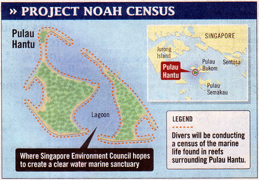
Graphic Courtesy of WildSingapore
Pulau Hantu is made up of two smaller islands: Hantu Besar and Hantu Kecil.
The map above suggests there these two islands are well separated and that there are corals around each of the smaller islands.
In reality, there is a shallow lagoon between the two islands. At low tide, this lagoon is exposed out of water. At high tide, the water reaches about 1.5-2m in height on average. This allows comfortable and safe swimming. While snorkelling is possible, diving is not practical in the lagoon as it currently is.
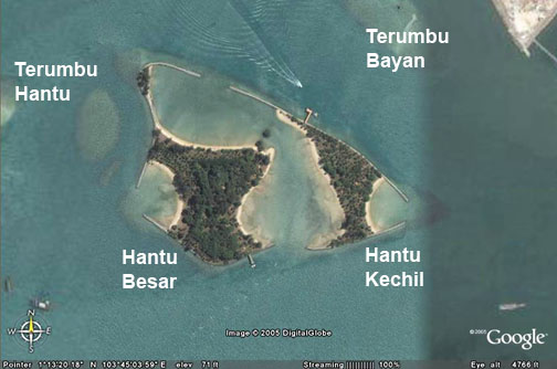
Graphic Courtesy of WildSingapore
Coral reefs have regenerated outside the man-made seawalls. There are several submerged reefs near Pulau Hantu. These are called 'terumbus'.This lagoon and the reef flats are already teeming with marine life.
To 'build' the reef in this lagoon will probably involve extensive changes to the depth of the lagoon. What will impact be on existing marine life there and in the surrounding reef flats and terumbus?
Other issues...
"The divers, however, face a difficult task because of poor visibility caused by silt suspended in the water. It can be so bad that 'you have to bump into coral to notice them', said Project Noah manager Spencer Lewis." Will SUF divers involved in the census be properly trained so as not to damage our reefs as they do their census?
Professionals, scientists and regular divers in our waters generally know how to manage underwater activities without damaging our reefs. They would certainly not 'bump' into corals to find them ).
Project NOAH Presentation Minutes:
-Mr Howard Shaw (HS) informed that the 'end objective' for the NOAH 'programme' was to strive for a marine reserve in Singapore. 'Programme' is a more accurate term as it encompasses several 'projects' rather than a single effort.
-Another end objective was to have a 'clear water diving area in Singapore'
-The ideas were 'literally toyed with' and various consultants including engineers were approached
-It was concluded that no 'artificial environment' would be created
-These measures were explored:
--> Biological and mechanical means
--> Create barriers
-However, this 'natural' measures were deemed to be phenomenally expensive with other issues such as ownership, maintenance and whether it is actually possible
-HS stated that 'not even I know how it'll work' with regards to artificial barriered reef
-As such, project objective was realigned and clear water area deemed 'not such a feasible idea'
-Instead, SEC wants an area to be protected and will seek a conservative stance, with the support of the private sector, to conduct an extensive marine census, to determine what's there.
-With the results, a report will be put together for the planning authorities to push for protection.
-HS understands that a lot of survey work is already done, and wishes to 'open our arms to other groups to contribute information'.
-SEC will act as a facilitator, and has coordinated efforts and presentations for this project.
-The census will be conducted over 6 months, with 300+ dives.
-As of now, there's no idea of what to do in Phase II, the barriered reef plan is 'just talk' and there are 'no concrete plans'.
-As for dredging of the lagoon and coral transplantation, SEC has no intention of carrying those out, and wishes to understand what's out there instead.
-HS shared that he's a diver himself, and has dived in 'brown waters' like the Johor Straits. He noted clear water areas around mussel beds, which could be looked into in the future, but stated that SEC is 'not expert' in this area.
-HS concluded by stating that SEC's doors are open at all times.
-Mr Sydney Chew (SC) shared what was presented at the press conference.
-SC stated that he does not represent SUF, and he also cares for the environment
-NOAH is a concept
-SC informed that land reclamation is not going to stop, and the marine environment is thus 'not ideal for corals'
-Concept was inspired by 'illwinds from Sumatran forest fires'
-SC noticed that restricted areas in Singapore harbour more marine life, and that Hantu is an 'ideal island'.
-SC stated that Singapore has limited dive sites (Pulau Hantu, P. Jong and Sisters' Islands) and the greatest threat faced is silt and sedimentation, thus the plan for a 'clear-water domain'.
-Why conserve? 'Because it is ours'
-The floor then opened for questions
Adapted from: Hantu Blog, Wild Singapore and the Blue Water Volunteers Website.
Labels: Dive News
posted by dragondiver at 10:21 am
|
0 Bubbles Created
![]()
![]()